COMMAND CENTER
SECTOR NORTH CAROLINA
AREA OF RESPONSIBILITY
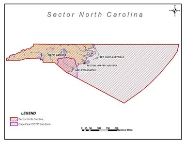
The boundary of Sector North Carolina Marine Inspection Zone and COTP zone starts at the sea on the North Carolina-Virginia border at 36 degrees 33 minute N. Latitude, 75 degrees 52.5 minutes W. Longitude, and proceeds westerly along the North Carolina-Virginia boundary to the Tennessee boundary; Thence southwesterly along the North Carolina-Tennessee boundary to the Georgia boundary; Thence easterly along the North Carolina- Georgia boundary to the South Carolina boundary; thence easterly along the North Carolina-South Carolina boundary on the sea at 36 degrees 32.69 minutes N. latitude, 75 degrees 50.17 minutes W. longitude. The offshore boundary starts at the North Carolina-South Carolina border and proceeds southeasterly to the outermost extent of the EEZ at 30 degrees 54.93 minutes N. latitude, 73 degrees 00.06 minutes W. longitude; Thence northeasterly along the outermost extent of the EEZ to a point at 36 degrees 33 minutes N. latitude, 67 degrees 44.09 minutes W. longitude; Then west to the North Carolina-Virginia border at the point 36 degrees 33 minutes N latitude, 75 degrees 52.5 minutes W.